
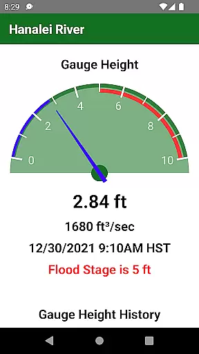
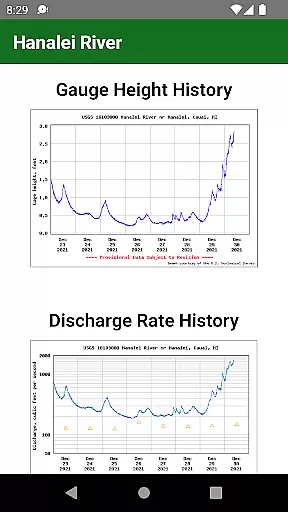
Hanalei River is a specialized weather application designed to provide real-time river gauge data for the Hanalei River on Kaua'i. The app's core functionality allows users to quickly check the river's height during heavy rains, ensuring safety and preparedness.
In addition to river gauge information, the app also offers access to Hanalei Initiative's road camera, enabling users to determine if roads are open to traffic. This feature is particularly valuable for locals and visitors who need to navigate the area during severe weather conditions.
Looking ahead, the developers plan to introduce tide data, push notifications for rising river levels, and gauge data for all Kaua'i rivers, further enhancing the app's utility for weather monitoring and safety planning.
The app boasts several distinctive features that cater to weather-conscious users. First and foremost, it provides instant access to the Hanalei River's gauge height, which is crucial for assessing flood risks during heavy rainfall on Kaua'i.
A secondary but equally important feature is the integration of Hanalei Initiative's road camera feed. This allows users to visually confirm whether roads are accessible, adding an extra layer of convenience and safety when planning travel routes in adverse weather.
Future updates promise even more functionality, including tide data specific to Hanalei, real-time push notifications when the river level rises, and comprehensive river gauge data covering all rivers on Kaua'i. These enhancements will solidify the app's position as an indispensable tool for both residents and tourists concerned with local weather patterns.
Accurate weather forecasting is essential for planning and safety, particularly in regions prone to heavy rains. The Hanalei River app provides reliable gauge height data, ensuring users have the most up-to-date information on river levels during inclement weather on Kaua'i.
The app sources its data from trusted meteorological services, providing credible insights into current conditions. This commitment to data accuracy ensures that residents and visitors can make informed decisions about travel and activities around the Hanalei area.
By integrating real-time updates and planned features like tide data and push notifications for rising water levels, the app enhances user preparedness. These proactive alerts empower users to respond promptly to changing weather patterns, safeguarding both people and property.
Understanding weather patterns over time and space is crucial for effective planning. The Hanalei River app offers comprehensive temporal and spatial forecast coverage, enabling users to anticipate changes in river heights across different locations on Kaua'i.
With future updates promising river gauge data for all Kaua'i rivers, the app aims to expand its geographical reach. This extended coverage will allow users to monitor multiple river systems, providing a holistic view of the island's hydrological status.
In addition to current gauge readings, the inclusion of tide data will offer deeper insights into coastal and riverine interactions. Such detailed forecasting empowers users to plan their activities with greater confidence, knowing they have access to extensive and precise environmental data.
Real-time river data
Road camera integration
User-friendly interface
Local community focus
Proactive safety alerts
Limited to Kaua'i region
Dependent on external data
No offline functionality
Basic UI design
Fewer features than competitors
Live Weather Forecast app with acu weather radar, weather alert & weather widget
 4.80
4.80
Live weather forecast for your everyday life
4.60
Weather radar, hyperlocal tracker and weather maps: follow your weather station
4.80
Accurate Weather App: various widgets, real-time storm radar, hurricane tracker.
4.50
Track lightning strikes with our thunderstorms map, radar and lightning alarm.
4.70
NOAA forecast & radar for your exact location.
4.80
Check room temperature with this indoor thermometer. thermostat & hydrometer
4.70
Stay Ahead Of Changing Weather Conditions
4.00
Live NOAA weather app to track storm, rain, wind, lightning & real local updates
4.20
Local weather forecast app, your personal 7*24 local weather forecast assistant.
4.90
Weather for Indiana, Kentucky and Ohio
4.90
Live Alabama weather from James Spann—forecasts, radar, alerts, Spanncams.
4.70
The weather channel, tiempo weather forecast, weather radar & weather map
4.70
Get accurate rainfall and snowfall totals for pinpoint locations on a map.
4.60
Track rainfall totals with ease using our rain gauge app. Accurate rain tracker.
4.50
Personal Weather Station PRO - Meteo monitor to check your WU info and charts.
4.20
Live weather radar, widgets & forecasts. Track rain, storms & temperature.
4.20
Check forecasts, watch live news & track storms with FOX Weather.
3.80
Most precise & accurate compass app give true North South East West directions.
3.00


User Reviews